![](/images/other/stat-length.png)
![Excursión A pie Le Vernet - AR Roussimal- Vieille cabane- Cabane des Têtes- Val pousane - Photo](https://media.geolcdn.com/t/1900/400/209ef688-5571-4538-b76d-15017869ac6f.gif&format=pjpeg&maxdim=2)
AR Roussimal- Vieille cabane- Cabane des Têtes- Val pousane
Monique14
Usuario
![Longitud](/images/other/stat-length.png)
![Altitud máxima](https://static1.geolcdn.com/siteimages/upload/files/1508320355ic_sort_altitude_max_24dp.png)
![Desnivel positivo](https://static1.geolcdn.com/siteimages/upload/files/1508320355ic_sort_den_pos_24dp.png)
![Km-Effort](/images/other/stat-length.png)
![Altitud mínima](https://static1.geolcdn.com/siteimages/upload/files/1508320355ic_sort_altitude_min_24dp.png)
![Desnivel negativo](https://static1.geolcdn.com/siteimages/upload/files/1508320355ic_sort_den_neg_24dp.png)
![Boucle](https://static1.geolcdn.com/siteimages/upload/files/16400158638029165_repeat_loop_refresh_sync_direction_icon.png)
![A pie](https://static1.geolcdn.com/sitytour/trail-icons/100.png)
5h00
Dificultad : Medio
![Escanee este código QR para abrir la excursión en la aplicación SityTrail](https://capi.geolives.com/qq0zvz2zws4bq2lad0pu/sitytour/trails/3691075/qr.png?size=200)
Aplicación GPS de excursión GRATIS
A propósito
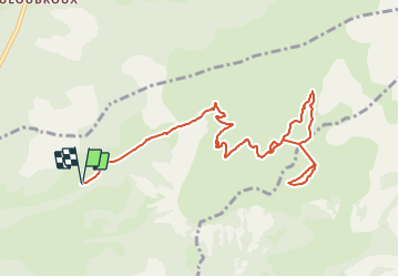
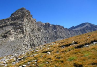
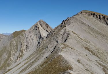
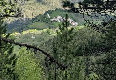
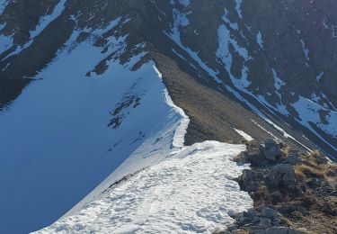
Ruta A pie de 12,5 km a descubrir en Provenza-Alpes-Costa Azul, Alpes de Alta Provenza, Le Vernet. Esta ruta ha sido propuesta por Monique14.
Descripción
- De la mairie, en voiture en direction de Roussimal, rejoindre la piste en face et se garer.
- Monter cette piste pendant 1h environ, traverser 3 gués, arriver à une barrière.
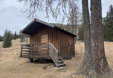
- Continuer pendant 1h ( avec en vue la fontaine du Gorgeas, la Vieille cabane (1773m) se trouve en retrait à droite.
- Reprendre le chemin pour arriver à la cabane des Têtes (1873m).
- Repérer la piste qui rejoint la crête qui accéde à la cabane de Val Pousane (1812m).
- Le retour se fait en remontant sur la crête pour basculer à gauche vers la Vieille cabane par l'itinéraire de montée.
Localización
Comentarios
Excursiones cerca
![Excursión Senderismo Le Vernet - LE VERNET . COL DU MAL D HIVER . COL DU LABOURET . O L M - Photo](https://media.geolcdn.com/t/375/260/f7633ca9-7d5b-44f5-917e-1ea1f5fb10ea.jpg&format=jpg&maxdim=2)
![Senderismo Senderismo](https://static1.geolcdn.com/sitytour/trail-icons/101.png)
Senderismo
![](/images/other/stat-length.png)
![](https://static1.geolcdn.com/siteimages/upload/files/16400158638029165_repeat_loop_refresh_sync_direction_icon.png)
![Excursión Senderismo Le Vernet - VERNET . col de Mariaud. Les 3 cabanes o - Photo](https://media.geolcdn.com/t/375/260/ext.jpg?maxdim=2&url=https%3A%2F%2Fstatic1.geolcdn.com%2Fsiteimages%2Fupload%2Ffiles%2F1553511878bg_sport_marche.png)
![Senderismo Senderismo](https://static1.geolcdn.com/sitytour/trail-icons/101.png)
Senderismo
![](/images/other/stat-length.png)
![](https://static1.geolcdn.com/siteimages/upload/files/16400158638029165_repeat_loop_refresh_sync_direction_icon.png)
![Excursión Senderismo Seyne - SEYNES LES ALPES . Grand puy , montagne de la Blache , cabane du Mulet o l s - Photo](https://media.geolcdn.com/t/375/260/0a85776d-4fbe-44a9-8b16-bf4257f31cc2.jpg&format=jpg&maxdim=2)
![Senderismo Senderismo](https://static1.geolcdn.com/sitytour/trail-icons/101.png)
Senderismo
![](/images/other/stat-length.png)
![](https://static1.geolcdn.com/siteimages/upload/files/16400158638029165_repeat_loop_refresh_sync_direction_icon.png)
![Excursión Senderismo Seyne - tour de tourtourel - Photo](https://media.geolcdn.com/t/375/260/ext.jpg?maxdim=2&url=https%3A%2F%2Fstatic1.geolcdn.com%2Fsiteimages%2Fupload%2Ffiles%2F1553511878bg_sport_marche.png)
![Senderismo Senderismo](https://static1.geolcdn.com/sitytour/trail-icons/101.png)
Senderismo
![](/images/other/stat-length.png)
![](https://static1.geolcdn.com/siteimages/upload/files/16400158638029165_repeat_loop_refresh_sync_direction_icon.png)
![Excursión Senderismo Prads-Haute-Bléone - Estrop par Pic des Têtes - Photo](https://media.geolcdn.com/t/375/260/ext.jpg?maxdim=2&url=https%3A%2F%2Fservices.sitytrail.com%2FGeolivesWS%2FDownloadMedia.ashx%3FTrailID%3D452152%26Media%3D673d9b5f-8851-4b41-9daf-25b8a44f9005.jpg)
![Senderismo Senderismo](https://static1.geolcdn.com/sitytour/trail-icons/101.png)
Senderismo
![](/images/other/stat-length.png)
![](https://static1.geolcdn.com/siteimages/upload/files/16400158638029165_repeat_loop_refresh_sync_direction_icon.png)
![Excursión Senderismo Seyne - dos de chameau 1165m 12kms - Photo](https://media.geolcdn.com/t/375/260/20594f73-6d6a-4dc1-92d9-8c17fbfc97a8.jpg&format=jpg&maxdim=2)
![Senderismo Senderismo](https://static1.geolcdn.com/sitytour/trail-icons/101.png)
Senderismo
![](/images/other/stat-length.png)
![](https://static1.geolcdn.com/siteimages/upload/files/16400158638029165_repeat_loop_refresh_sync_direction_icon.png)
![Excursión Senderismo Le Vernet - grisonniere montagne ubac belliers960m 15kms - Photo](https://media.geolcdn.com/t/375/260/be9eca9e-a641-4422-8867-7fa326600209.jpg&format=jpg&maxdim=2)
![Senderismo Senderismo](https://static1.geolcdn.com/sitytour/trail-icons/101.png)
Senderismo
![](/images/other/stat-length.png)
![](https://static1.geolcdn.com/siteimages/upload/files/16400158638029165_repeat_loop_refresh_sync_direction_icon.png)
![Excursión Senderismo Seyne - Seyne première bosse dos de chameau 9km 950m - Photo](https://media.geolcdn.com/t/375/260/5e0390cb-740a-4758-8977-417cce7cc0a2.jpg&format=jpg&maxdim=2)
![Senderismo Senderismo](https://static1.geolcdn.com/sitytour/trail-icons/101.png)
Senderismo
![](/images/other/stat-length.png)
![](https://static1.geolcdn.com/siteimages/upload/files/16400158638029165_repeat_loop_refresh_sync_direction_icon.png)
![Excursión A pie Le Vernet - Boucle route des Béliers-Le col de Mariaud-Barre des Béliers-Col de la Grisonnière-Cabane du berger - Photo](https://media.geolcdn.com/t/375/260/2db42dd5-9a9c-4bfd-a26c-d699435386fb.jpg&format=jpg&maxdim=2)
![A pie A pie](https://static1.geolcdn.com/sitytour/trail-icons/100.png)
A pie
![](/images/other/stat-length.png)
![](https://static1.geolcdn.com/siteimages/upload/files/16400158638029165_repeat_loop_refresh_sync_direction_icon.png)